This hunt was one of my proudest works.
To solve this hunt, the optimal first step would be to drive to the arrow that is right by the Red Pine trailhead in LCC. The map has an image associated with this location that looks like this:
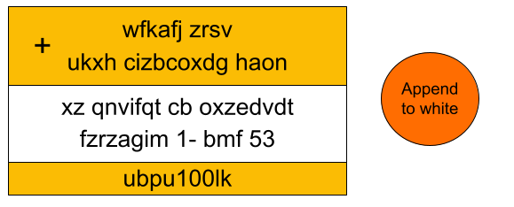
Across the street from the location of the first arrow are some signs that look like this:
Combining the text using a Vernam cipher (pretty much just "adding" the letters together (A=1)) produces this result:
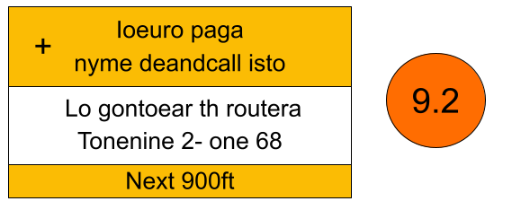
The first part of the message reads, "Io Europa Ganymede and Callisto" (These are the four largest moons of Jupiter).
The next part of the message reads, "Log on to Earth router at one nine 2 one 68 9.2". As an IP address, that would read: 192.168.9.2
At this point, with Jupiter represented and Earth mentioned, the searchers are meant to start thinking of the arrows in terms of planets.
The intended solution is to figure out which arrow represents Earth and go straight there with the intent to connect to a router. Alternatively, searchers could visit the other arrows if they had not yet figured out that the arrows represent planets.
I made little video clips to explain each of the arrows in the Lake Blanche area. From North to South those arrows represent Mars, Venus, Mercury, and Earth
MarsThis point of interest was close enough to Lake Blanche that I kept my impact pretty subtle. I didn't want random people to find what I'd done and feel like the area had been vandalized or something. So I just used rocks to create this symbol:♂ | |
VenusAt this arrow location I just attached a small plate with a 'V' painted on it to one of the dead trees. When I went to recover the plate later, I could not find it. So apologies to anyone if there was any confusion/frustration from not finding anything at this arrow. | |
MercuryThis location on the map indicated to search at the "nearest tree". On the tree I fastened a metal plate that had the words, "SLICK QUIVER" on it. These anagram to, "QUICK SILVER" which is a common nickname for the element Mercury. | |
EarthHere is where a bunch of stuff comes together! Hopefully by the time you get to this arrow you've realized that the arrows all represent the locations of planets (centered around Sundial peak). With that in mind, you should arrive at this "Earth" arrow expecting to connect to a router. I know that is counterintuitive to expect a router in the middle of no where, but that is exactly what I achieved with a solar-charger and a little device called a NodeMCU hidden in the trees just about 20 meters higher up the incline.The SSID is called "Earth". There is no password. Connecting to the router and entering the IP address 192.168.9.2 into a browser brings up the following text: This represents the location of Earth on April 1st, 1981 | |
UranusThis location simply had the Uranus symbol (♅) painted on a rock. I don't think anyone bothered to go there, which is totally fine. I mostly wanted to include it so that I would have 6 arrows on the map. | |
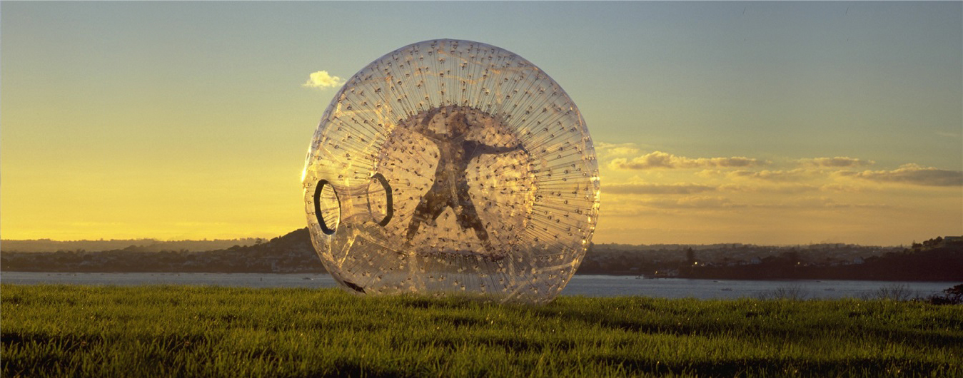
Other NotesImagine the complexities of constructing this hunt. I decided early on to center my planets around Sundial Peak, but there was A LOT of trial and error with different dates, scales, and orientations. I had to make sure none of the arrows were on dangerous terrain. I had to make sure Saturn would end up in a practical location. But the hardest part was that I had to make sure that at least one of the arrows took people somewhere where there was text that I could use. I was thrilled when I tried this date and found a road sign full of text right by the Jupiter arrow.For a long time now, I have been wanting to make a scale model of the solar system in two dimensions for some given date. I guess I still didn't quite do that since I did not have physical objects to represent the planets at each of the arrow locations, but I got pretty close to the spirit of the model with this treasure hunt. Imagine a zorb ball (14 ft diameter) on top of Sundial peak and a little ping-pong ball to represent Earth a quarter mile away to the South; Uranus is a cantaloupe way over by Pittsburg lake, etc. |
Here is a map showing all the locations with labels.
Congratulations to Eric and his sister Ann!
They found the Hidden Saturn, this Arrows Saturn, and they were formidable contenders for every other Saturn.
They also kept me in the loop about what they were thinking, commented on the message board, helped me identify/fix errors on the website and in the search area, and were just genuinely enthusiastic about the hunts from start to finish, which I greatly appreciated!
Eric wrote an extensive report of this solve:
It took only two hiking attempts to find Arrows, but it was 5 hours of searching a relatively small area (the tracking app said I went a total of 4.2 miles on mostly 30-40 degree slopes while searching). Including the trail, it was 14.5 miles and 3700 feet of elevation gained (and lost) total.
We didn't really try to solve Arrows until after Shapes was found. I had decoded the sign at Arrow 1 in July due to working on Shapes (Shapes 166 revealed what kind of cipher it was). At that point, I thought we needed to go somewhere in the boundaries and find a Wi-Fi network named Earth. We "wardrove" (driving while running an app which scans for Wi-Fi networks) over the next couple of weeks (while doing other things, like hikes for Nectar and Verses) and didn't find the "Earth" router. Then I decided that the router must be at one of the arrows at Lake Blanche, but we were busy with other hunts and didn't find the time to get up there. At that point, I started getting a suspicion that the arrows are a model of the solar system (each arrow representing a planet). But I didn't do anything else on Arrows until this week.
That theory was bolstered by the 18-Sept hint that you didn't need to visit the arrows and that the hunt could be called "System". We ended up not hiking to any of the Arrows. This past Sunday, I took the distance of each arrow from Sundial Peak and found that the relative distances were pretty close to the average of the real planets' relative distances from the Sun, which confirmed the theory.
| Planet | Actual Distance | Arrow Distance |
|---|---|---|
| Mercury | 0.39 AU | 0.43 |
| Venus | 0.72 AU | 0.65 |
| Earth | 1.00 AU | 1.00 |
| Mars | 1.52 AU | 1.30 |
| Jupiter | 5.20 AU | 5.32 |
| Uranus | 19.20 AU | 18.24 |